Wildlife and Scenery

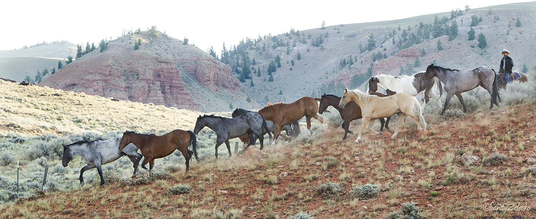
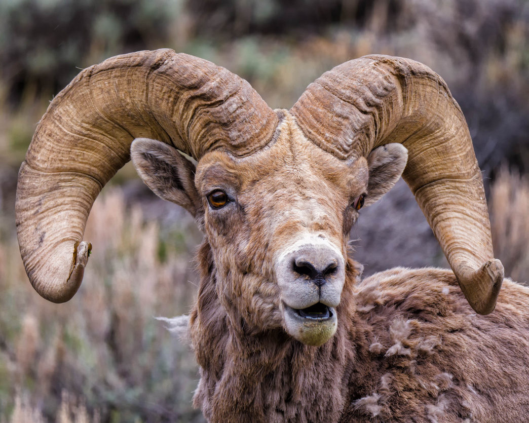
Dubois is located in the niche below the intersection of two great mountain ranges: the volcanic Absarokas spilling eastward from Yellowstone, and the southeastward-ranging Wind River Mountains, the tallest mountain range in Wyoming. Isolated and uncrowded, the valley offers spectacular opportunities for wildlife viewing.

Much of it shaped by volcanoes and earthquakes and carved by glaciers, the area is a geologist’s playground and a living textbook in ecology, shifting from high alpine desert to brilliant arid badlands within a few dozen miles.

Isolated and uncrowded, the valley offers spectacular opportunities for wildlife viewing. Watch the landscape for deer, antelope, and elk. If you’re very lucky, you might run across one of our nationally recognized bighorn sheep. If you’re careful, you might even be able to safely glimpse a bear or a wolf.

Scan the skies for eagles, falcons, owls, and brilliant mountain bluebirds. Look down for Indian paintbrush, masses of lupine, carpets of multicolored wildflowers, or the bright bulbs of cactus flower.

Dubois Fish Hatchery

Visitors are welcome at the Dubois Fish Hatchery five miles east of town, which nurtures most of the cutthroat trout eggs for the entire state of Wyoming, as well as caring for young rainbow, golden, ... Read More

Visitors are welcome at the Dubois Fish Hatchery five miles east of town, which nurtures most of the cutthroat trout eggs for the entire state of Wyoming, as well as caring for young rainbow, golden, brook and brown trout. The cutthroat trout eggs are spawned in the Wind River mountains and reared here for release into high mountain lakes all over the state.

A facility of the Wyoming Game & Fish Department since 1922, the fish hatchery is located about five miles southeast of town. Look for signs on the highway.

Show Less

National Bighorn Sheep Interpretive Center

One of the nation's largest herds of wild bighorn sheep live in the mountains near Dubois. The exhibits at the National Bighorn Sheep Interpretive Center portray the habitat and habits of these remark... Read More

One of the nation’s largest herds of wild bighorn sheep live in the mountains near Dubois. The exhibits at the National Bighorn Sheep Interpretive Center portray the habitat and habits of these remarkably adaptive animals, or you may be able to spot them on the cliffs during one of the center’s guided tours.

Between October and March, the Center’s winter tours provide a wonderful opportunity to view wildlife on their primary winter range, at Whiskey Mountain. Tours typically start at 9:00 AM and average 3-4 hours. The cost is $100 per person. A minimum of two guests is required (or one person can do the tour for $200); our van seats 7 people. We appreciate at least 48-hour notice to book tours. Call or email us at info@bighorn.org for further information.

Show Less

Shoshone National Forest

Set aside in 1891 as part of the Yellowstone Timberland Reserve, the wilderness that surrounds Dubois is the part of the first national forest in the United States. Sections of its vastness easily acc... Read More

Set aside in 1891 as part of the Yellowstone Timberland Reserve, the wilderness that surrounds Dubois is the part of the first national forest in the United States. Sections of its vastness easily accessible from Dubois include four good regions for hiking, fishing, and other back-country activities:

  • Trail Lakes and Whiskey Basin: Three placid lakes strung out like beads on a necklace. Native American petroglyphs carved into the boulders. Bighorn sheep on the high peaks in autumn. A great hike up to a glacial lake less than one steep, rocky mile above the trailhead. Take Highway 26/287 east from Dubois for about 3½ miles to Whiskey Basin/Trail Lake Road on the right. The trailhead is about 8 miles up this gravel road.
  • Horse Creek area and Double Cabin: From a small campground deep in the wilderness along a shallow creek, two trails head north and another leads south, one to a petrified forest. To reach the trailhead at the Double Cabin campground, head north from town on Horse Creek Road and stay on Forest Road 285. The campground is 28 miles from town. Another campground and fishing area are at Horse Creek, only 12 miles along
  • Sheridan Creek: Popular with hunters, this camping area networked with old logging trails offers wonderful views of the craggy peaks of the Absaroka range to the north. Drive about 17 miles west of town on Highway 26/287 and look for Forest Road 532 heading off to the south.
  • Brooks Lake area: Here you can fish the quiet lake surrounded by a cathedral of granite peaks, or hike to two beautiful lakes high in the mountains. The four-mile round trip to Jade Lake is great for a family outing, or the trek up to Bonneville Pass, six miles out and back, leads to a high meadow that explodes with wildflowers throughout much of the summer. Take highway 26/287 about 23 miles west of Dubois to the Brooks Lake turnoff on the right. Follow the gravel road about 5 miles to the Brooks Lake campground for the Jade Lake trail. For the Bonneville Pass trailhead turn onto Forest Road #516 at about 4 miles along, and follow it to the small parking lot after less than 2 miles.
Show Less

Town Park and Scenic Overlook

You can enjoy the great outdoors without even leaving town. For those with less physical ability, energy, or time, visiting the town park and the Scenic Overlook is a low-exertion way to capture many ... Read More

You can enjoy the great outdoors without even leaving town. For those with less physical ability, energy, or time, visiting the town park and the Scenic Overlook is a low-exertion way to capture many of the natural joys of Dubois.

You can’t camp in the town park, but you can have a picnic there. Kids can use the skate park and the playground, adults can play in the tennis courts and everyone can enjoy the Riverwalk. Extending on both sides of the river, the paved and handicapped-accessible walkway is lined by willow, juniper, sagebrush, and wild roses. There’s a small beach on the far side of the boardwalk footbridge.

Across the highway and slightly to the west, look for the large Scenic Overlook sign and the steep gravel roadway leading up to the high ridge. You can drive to the top or hike up for a great short workout. Trails suitable for mountain biking criss-cross the the plateau halfway up. The summit offers a spectacular view of the surrounding mountains. Here you can see all 3 mountain-building processes (volcanic, tectonic, and sedimentary) from one location. Look for the information signs beside the circular roadway at the top.

Show Less